by Catherine Schmitt
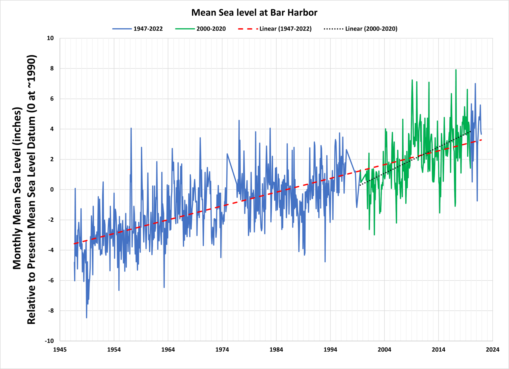
Since 2019, we have been monitoring the effects of sea level rise on Mount Desert Island. We know from the tide gauge at Bar Harbor that local sea level relative to the shoreline has risen eight inches since 1950. We also know that the rate of sea level rise, once relatively constant, has accelerated as the ocean expands with warmth and swells with runoff from melting glaciers.
Between 2000 and 2020 sea levels rose twice as fast (0.18 inches or 4.5 millimeters per year) as during the previous fifty years (0.09 inches or 2.3 millimeters per year).
Higher sea levels mean that storm waves and flooding are also higher. The worst-case scenario of a storm arriving at the same time as a king tide occurred December 23-25 2022, when water levels reached a peak of 14.42 feet, and then again in January 2024. These storms brought an increase of THREE and FOUR FEET above the late twentieth century average monthly high tide of 11.37 feet, and a glimpse of average sea levels in the future.
It’s hard to keep up. Things are changing so fast that long-term trends and averages, while more reliable, become irrelevant when it comes to making decisions about the future. But sea level rise is also predictable, especially compared to other climate-related changes affecting Acadia. It is more important than ever to get out on the landscape and pay attention to the edge of the sea.
What can you do?
*Document sea levels during high tides and storms.
Changes in sea level are especially noticeable at monthly “spring” tides (what NOAA refers to as “higher high water” and “lower low water”). The highest of these are sometimes called “king tides” and occur during certain times of the year, depending on the alignment of the Earth, moon, and sun, as well as seasonal ocean currents. Share photos of high tides and storms to the Gulf of Maine King Tides Project on Anecdata. The communities of Southwest Harbor and Tremont are also invited to participate in Gulf of Maine Research Institute’s Community Flood Monitoring. The 2025 “wicked high” (and low) tides arrive October 8 and November 5.
*Be prepared for rising seas.
The future shoreline may look very different than it does today, but we will always be a coastal community. How should we prepare?
- Preserve land adjacent to marshes and beaches.
- Elevate and flood-proof buildings by moving electrical outlets and wires higher in the walls, and use building materials that can be replaced in case of floods. Check out SeaLevelRise.org for practical advice for homeowners, communities, and states.
- Plan bridges, roads, and other public infrastructure to accommodate high water.
- Talk to your town manager to find out what plans they are making.
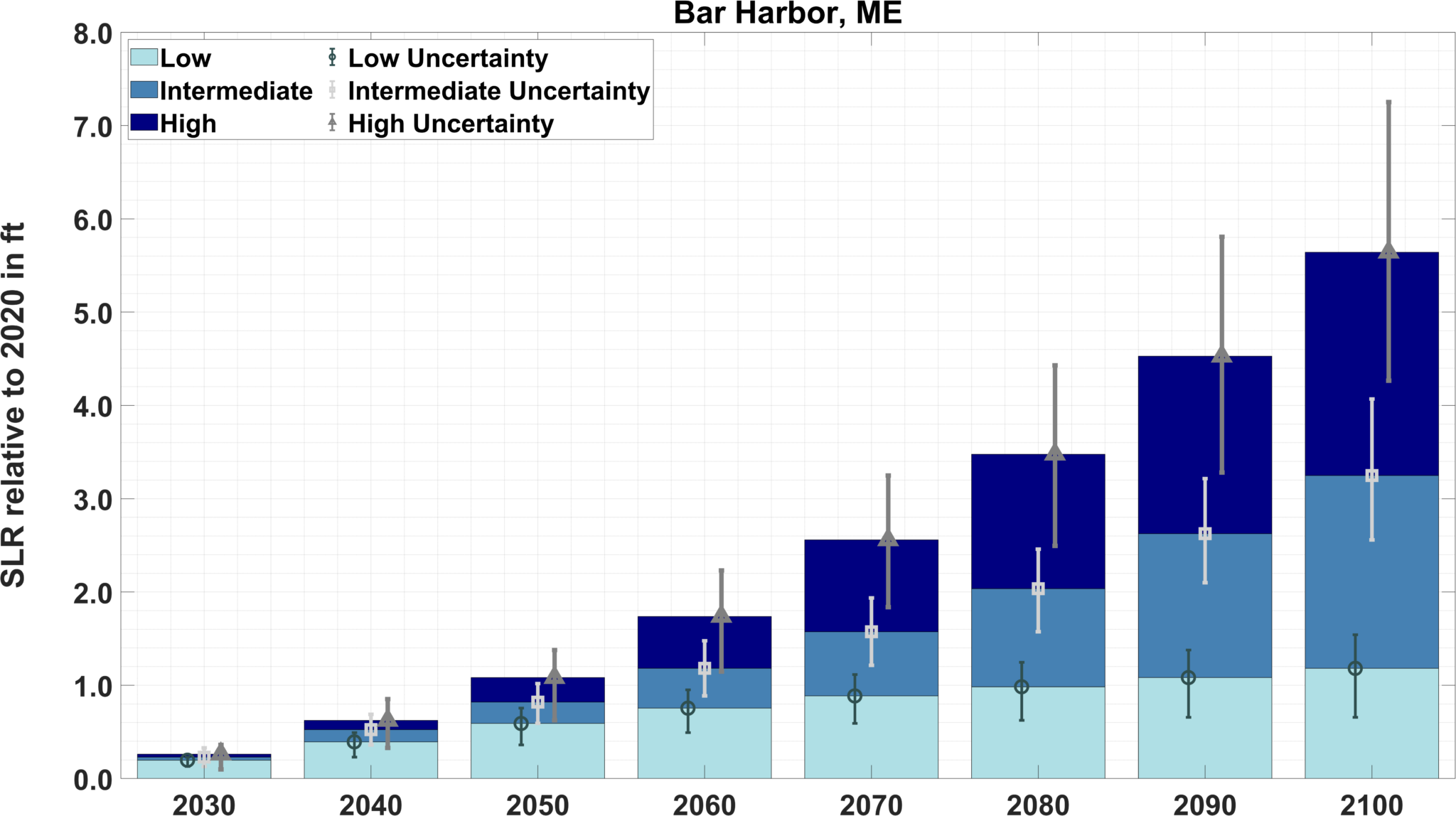
While tomorrow depends on the actions we take today to reduce fossil fuel extraction and burning, projections updated by NOAA, NASA, and other federal agencies in 2022, suggest sea levels at Bar Harbor will rise another foot by 2050 and three feet by 2100.
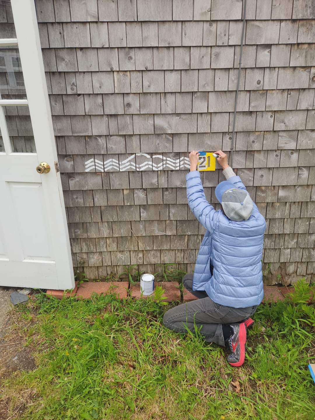
In partnership with artist Jennifer Steen Booher and Mount Desert Island Historical Society, we are marking some of these actual and projected sea levels. To date, we have completed six installations:
- Visit The Oceanarium to see the height of storm surge flooding in December 2022 and January 2024, how high water levels might get during a similar storm in 2050 and 2100, and what future average sea levels might be like in the surrounding marsh and forest.
- In Somesville, look for the December 2022 flood height on the Somesville Dam and Fishway, documented by fisherman Rusty Taylor.
- In Bernard, volunteers helped mark future sea levels at Maine Coast Heritage Trust’s Kelley Farm Preserve.
- Tremont Consolidated School students marked 2050 and 2100 sea levels at their ball field and boat ramp.
- Volunteers helped us paint future sea levels on the shore at the Mount Desert Island Biological Laboratory during Family Science Night.
- Mount Desert Island High School students marked a private property in Bar Harbor during the October 2024 king tide.
Want to get out on the shoreline and try it yourself? Let us know!
References
Gulf of Maine King Tides Project
Sea level trend and future scenarios for Bar Harbor
2022 Interagency Sea Level Rise Projections
More information about the tide gauge at Bar Harbor and current and historical water levels at Bar Harbor