In Acadia
Northeast Temperate Network: Schoodic Institute-supported crews with the National Park Service Northeast Temperate Network continue long-term monitoring of birds, forests, intertidal, and wetland health.
Biodiversity Monitoring: Schoodic Institute staff and citizen scientists of all ages (and you, too!) help document animals, plants, fungi, and lichens using the applications iNaturalist and eBird, providing data that help us understand Acadia’s changing environment, including Schoodic Signals.
Climate Change Refugia: We survey for plants at the southern extent of their range to learn if Acadia’s diverse topography and coastal proximity provides “refugia” – areas where climate is not changing as much or as fast as the surrounding region.
Forest Insect Management: We are helping Acadia National Park develop a management plan for hemlock woolly adelgid, drawing upon local and regional experiences to provide information that will also benefit forests beyond park boundaries.
Sustainable Summits Project: Chris Nadeau, in partnership with the National Park Service and Northeastern University, leads a project to evaluate if planting plants from warmer locations can help summit restorations persist under climate change.
Wild Acadia: In partnership with the National Park Service, Wabanaki Nations, and Friends of Acadia, we are leading experiments to learn how to restore multiple ecosystems in Acadia. Chris Nadeau, Amina Wilson, Suzanne Greenlaw, and restoration technicians work in Bass Harbor Marsh, Great Meadow Wetland, and Summits, where experiments continue to determine the best way to restore soil and plants to Cadillac and other mountains given changing climate conditions.
Cross-System Subsidies: Hannah Webber and interns measure the “subsidy” of marine nutrients delivered by birds and mammals, such as mink and otter, feeding on mussels, crabs, and sea urchins at the forest edge.
Jonah Crab Monitoring: In late summer, Jonah crabs begin appearing in the intertidal zone. It is not clear if this is a natural phenomenon or the result of disease or changing water conditions. Hannah Webber, Shannon O’Brien, and technicians count and measure crabs along the shore of West Pond.
Northeastern Coastal Stations Alliance: Schoodic Institute is a member of the Northeastern Coastal Stations Alliance to study patterns of change across the Gulf of Maine. Hannah Webber and technicians collect data using standardized methods once per season.
Sea Level Rise Monitoring: Initiated in 2019, monitoring of tides, erosion, and sea level rise expanded in 2022 as part of Landscape of Change. Catherine Schmitt is the primary contact for this collaboration with Mount Desert Island Historical Society, Mount Desert Island Biological Laboratory, A Climate to Thrive, College of the Atlantic, Acadia National Park, and the related Coast Lines project partners artist Jennifer Steen Booher, The Oceanarium, Mount Desert Island High School, Tremont Consolidated School, and Maine Coast Heritage Trust.
Dragonfly Mercury Project: Initiated by Schoodic Institute in 2007, this project now engages people in national parks and other public lands across the United States to understand the spatial distribution of mercury pollution. Technicians sample dragonfly larvae at several locations in the park.
Schoodic Notes: Laura Sebastianelli, a professional wildlife tracker and trained sound recordist, works with Seth Benz and volunteers each June to record the calls and songs of breeding birds.
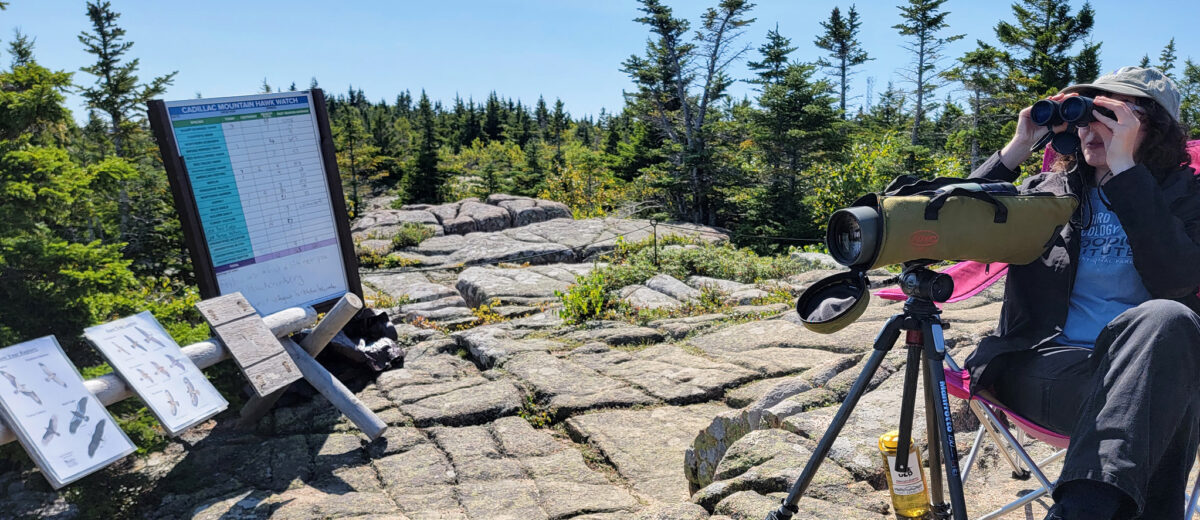
Hawk Watch: From late August through October each year, Seth Benz and a cadre of dedicated volunteers, along with Acadia National Park rangers, count eagles, hawks, falcons, and other birds as they pass over Cadillac Mountain during fall migration. Visitors are welcome!
Sea Watch: Each fall, Seth Benz and volunteers monitor the migration of thousands of sea birds from Schoodic Point. Counting takes place during early morning hours from September through mid-November. Visitors are welcome!
Beyond Acadia
Future Forests of Coastal Maine is a series of tree growth experiments at four conservation areas spanning a range of climate conditions, in partnership with Blue Hill Heritage Trust, Coastal Mountains Land Trust, and Waldo County Soil & Water Conservation District.
Schoodic Forest Preserve: We collaborate with Maine Coast Heritage Trust to conduct conservation science on this protected forest north of Route 186, including tree growth experiments and biodiversity monitoring.
The Mapping Mud Project, in collaboration with Manomet Conservation Sciences and Nearview LLC, as well as marine resource harvesters, seeks to characterize relationships between mudflat sediment and clam and worm populations, and how they are affected by storms at study sites in Penobscot and St. George.
Project ASCO (Assessing Seaweed via Community Observations) gets volunteers out into the intertidal zone to collect data about rockweed (Ascophyllum nodosum, or “Asco”), helping to answer the question, ”How much rockweed is there?”
Ocean Acidification: Every year the National Oceanic and Atmospheric Administration (NOAA) and the National Park Service collect water samples from the shore and from the deeper ocean to understand how the chemistry of coastal waters is changing with a changing climate. We collect samples from around Acadia to support this essential monitoring effort.