This is a list of current Schoodic Institute-led research projects with a field component, in and beyond Acadia. We also collaborate with the National Park Service to facilitate scientific research permits in Acadia.
In Acadia
Northeast Temperate Network: Schoodic Institute-supported crews with the NPS Inventory & Monitoring Program continue long-term monitoring of birds, forests, intertidal zones, and wetland health.
Biodiversity Monitoring: Schoodic Institute staff and volunteers of all ages (and you, too!) help document animals, plants, fungi, and lichens using the applications iNaturalist and eBird.
Climate Change Refugia: We survey for climate sensitive species at the southern extent of their ranges, to learn if relatively cool, foggy areas, like Schoodic Point, offer habitat that isn’t changing so fast.
Wild Acadia [a.k.a. Restoration Projects]: In partnership with Wabanaki Nations, the National Park Service, and Friends of Acadia, we are leading multiple projects to learn how to restore ecosystems and renew human relationships in Bass Harbor Marsh, Great Meadow Wetland, and Summits. A related project is developing management goals for 29 non-native invasive plant species that threaten the park’s natural and cultural resources.
Sustainable Summits Project: Chris Nadeau, in partnership with the National Park Service and Northeastern University, leads a project to evaluate if planting plants from warmer locations can help summit restorations persist under climate change.
Coastal Forest Food Webs: Hannah Webber, technicians, and Earthwatch volunteers are studying the “subsidy” of marine nutrients delivered into the forest by crows, mink, otter, and other animals as they feed on mussels, crabs, and sea urchins at the forest-ocean edge.
Sea Level Rise & Storm Monitoring: We monitor extreme tides, flooding, and storm impacts at multiple locations, including Sand Beach, Frazer Point, Thompson Island, and Seawall.
Jonah Crab Monitoring: In late summer, we measure Jonah crabs in the intertidal zone to learn if this is a natural phenomenon or the result of disease or changing water conditions.
NeCSA: Schoodic Institute is a member of the Northeastern Coastal Stations Alliance to study patterns of change across the Gulf of Maine. We collect data using standardized methods once per season.
Wildlife Monitoring: Staff biologists work with NPS to conduct field research and ecological monitoring of vulnerable species (such as threatened bats, peregrine falcons, and amphibians), sometimes also collaborating with volunteers.
Mount Desert Island Breeding Bird Survey: Gero Fellow Max Chalfin-Jacobs is leading this repeat of a 1990s survey of breeding birds across Mount Desert Island.
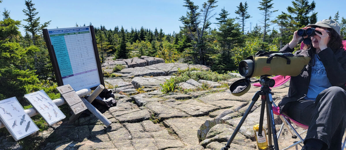
Hawk Watch runs from late August through October each year, when volunteers count eagles, hawks, falcons, and other birds as they pass over Cadillac Mountain during fall migration. Visitors welcome!
Sea Watch: From September through mid-November, staff and volunteers monitor the migration of thousands of sea birds as they pass Schoodic Point. Visitors are welcome!
Dragonfly Mercury Project: Initiated by Schoodic Institute in 2007, this project now engages thousands of people in hundreds of national parks and other public lands while assessing mercury pollution.
Schoodic Education Adventure: NPS and Schoodic Institute educators lead middle-school students into the woods and intertidal zone of Schoodic Point in this overnight outdoors program.
Archaeological Survey: More than 100 archaeological sites within Acadia National Park and Saint Croix Island International Historic Site are being assessed for their status and condition.
T.R.I.B.E. Inc. North American Indians Learning Center: We are conducting a special history study on T.R.I.B.E. (Teaching and Research in Bicultural Education), a Native education program that operated at Acadia National Park from 1970 to 1971.
Beyond Acadia
Schoodic Forest Preserve: We collaborate with Maine Coast Heritage Trust to conduct research on this protected forest north of Route 186, including tree growth experiments and biodiversity monitoring.
Future Forests of Coastal Maine is a series of tree growth experiments at four conservation areas spanning a range of climate conditions, in partnership with several land trusts.
The Mapping Mud Project is a collaboration with Manomet Conservation Sciences, Nearview LLC, and marine resource harvesters to survey clam and worm populations in mudlfats, before and after storms.
Clam Siphon Holes: Why is it that in some mudflats, soft-shell clams now concentrate almost exclusively in upper intertidal rocks and cobbles? Downeast harvest partners are helping map this phenomenon.
Crustacean Surveys: Every month we survey the intertidal crustacean guild, including lobster and crabs (Jonah, rock, Atlantic blue crab, mud fiddler crab, green, Asian shore) at locations statewide.
Project PIGS (Pursuit of Information Guiding Science): This research led by Maine Maritime Academy seeks to learn more about the red alga Vertebrata lanosa, also known as truffleweed or truffle seaweed.